
Chart
At Kayakstore.se you can find an extensive range of charts for your plotter. Using charts is essential to increase safety and optimize your fishing when you are out on the lake. We strongly recommend that you invest in a chart that fits your specific device.
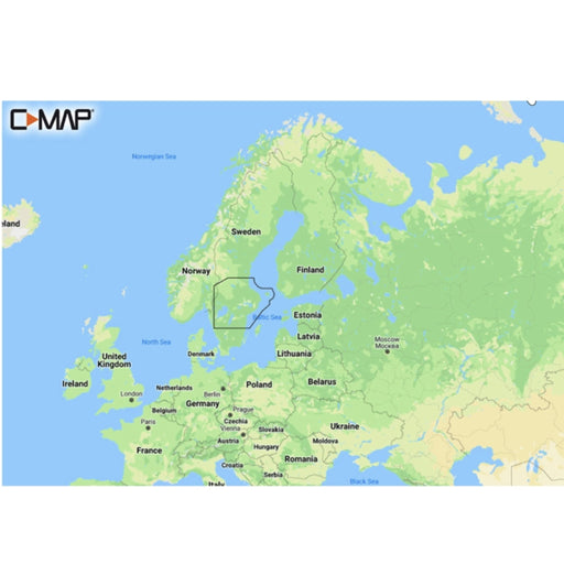
Are you looking for chart the Baltic Sea , chart Karlskrona , nautical charts kattegatt , Danish nautical charts, Finnish nautical charts or nautical charts in other parts of Europe, we have something for you all to offer!
We have charts for your plotter from many of the most well-known brands such as C-Map , Blue Chart, Navionics Charts , Garmin Charts, etc.
Original price
1 795 kr
Original price
1 795 kr
-
Original price
1 795 kr
Original price
1 795 kr
Current price
1 695 kr
1 695 kr
-
1 695 kr
Current price
1 695 kr
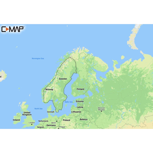
Garmin Navionics+ NSEU067R - Sweden, Lakes & Rivers (Sweden, Lakes & Rivers)
Garmin
In stock
S Garmin Navionics+ charts feature vivid colors, a streamlined interface, and a combination of ocean and sea content with a popular Navionics®-s...
View full details
Original price
1 795 kr
Original price
1 795 kr
-
Original price
1 795 kr
Original price
1 795 kr
Current price
1 695 kr
1 695 kr
-
1 695 kr
Current price
1 695 kr
Sale
Original price
1 790 kr
-
Original price
1 790 kr
Original price
1 790 kr
1 790 kr
1 790 kr
-
1 790 kr
Current price
1 790 kr
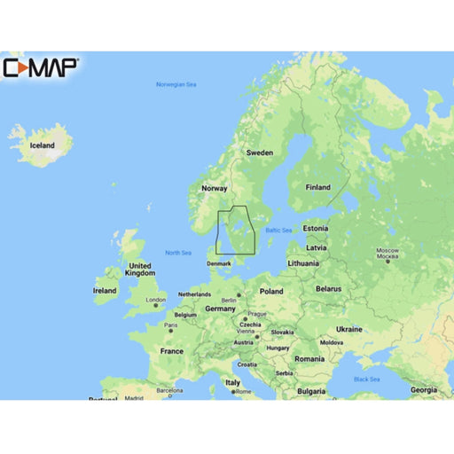
C-MAP DISCOVER - Scandinavia Inland Waters
C-MAP
In stock
Discover M-EN Y210 Scandinavia Inland Waters Discover has everything you need to make the most of your time on the water. Full vector graphics w...
View full details
Original price
1 790 kr
-
Original price
1 790 kr
Original price
1 790 kr
1 790 kr
1 790 kr
-
1 790 kr
Current price
1 790 kr
Original price
1 795 kr
Original price
1 795 kr
-
Original price
1 795 kr
Original price
1 795 kr
Current price
1 499 kr
1 499 kr
-
1 499 kr
Current price
1 499 kr
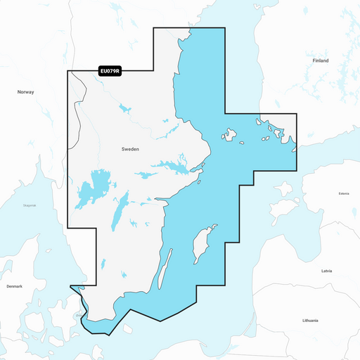
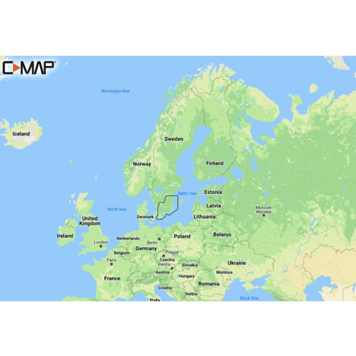
Garmin Navionics+ EU079R - Sweden, South - East
Garmin
In stock
The Garmin Navionics+ charts feature vibrant colors, a streamlined interface, and a combination of ocean and sea content with a popular Navionic...
View full details
Original price
1 795 kr
Original price
1 795 kr
-
Original price
1 795 kr
Original price
1 795 kr
Current price
1 499 kr
1 499 kr
-
1 499 kr
Current price
1 499 kr
Sale
Original price
2 590 kr
Original price
2 590 kr
-
Original price
2 590 kr
Original price
2 590 kr
Current price
2 190 kr
2 190 kr
-
2 190 kr
Current price
2 190 kr
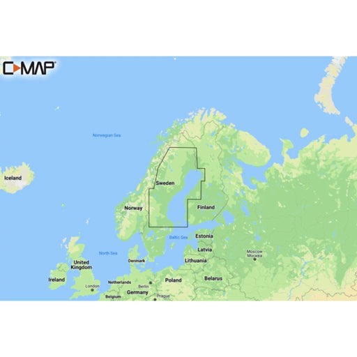
C-MAP DISCOVER - Baltic Sea
C-MAP
In stock
Discover M-EN Y055 Baltic Sea Continental C-MAP Discover - whether you're cruising or fishing, C-MAP® DISCOVER™ provides a selection ...
View full details
Original price
2 590 kr
Original price
2 590 kr
-
Original price
2 590 kr
Original price
2 590 kr
Current price
2 190 kr
2 190 kr
-
2 190 kr
Current price
2 190 kr
Sale
Original price
1 790 kr
Original price
1 790 kr
-
Original price
1 790 kr
Original price
1 790 kr
Current price
1 595 kr
1 595 kr
-
1 595 kr
Current price
1 595 kr
C-MAP DISCOVER - Västervik to Söderhamn
C-MAP
Low stock
C-MAP Discover - whether you're cruising or fishing, C-MAP® DISCOVER™ provides a selection of coverage areas with all the key features you need ...
View full details
Original price
1 790 kr
Original price
1 790 kr
-
Original price
1 790 kr
Original price
1 790 kr
Current price
1 595 kr
1 595 kr
-
1 595 kr
Current price
1 595 kr
Sale
Original price
2 795 kr
Original price
2 795 kr
-
Original price
2 795 kr
Original price
2 795 kr
Current price
2 499 kr
2 499 kr
-
2 499 kr
Current price
2 499 kr
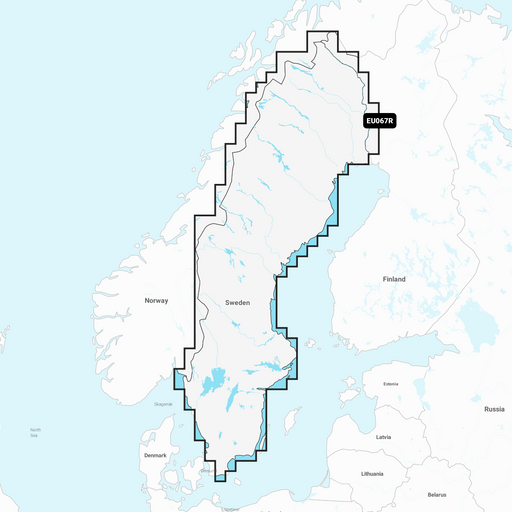
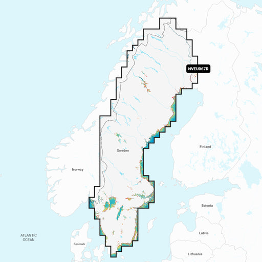
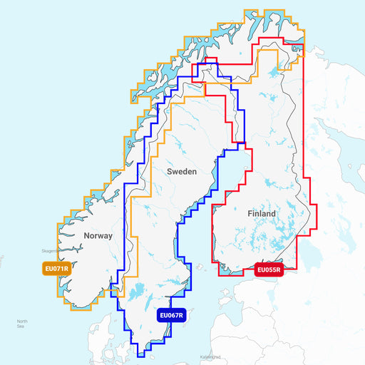
Garmin Navionics Vision+ EU067R Sweden, Lakes & Rivers
Garmin
In stock
Now with brand new RELIEF SHADING Relief Shading combines color and shadow to give you an easy-to-interpret and clearer picture of the bottom st...
View full details
Original price
2 795 kr
Original price
2 795 kr
-
Original price
2 795 kr
Original price
2 795 kr
Current price
2 499 kr
2 499 kr
-
2 499 kr
Current price
2 499 kr
Sale
Original price
2 629 kr
Original price
2 629 kr
-
Original price
2 629 kr
Original price
2 629 kr
Current price
2 299 kr
2 299 kr
-
2 299 kr
Current price
2 299 kr
C-MAP REVEAL - Scandinavia Inland
C-MAP
In stock
REVEAL - Scandinavia Inland Y580 C-MAP Reveal - for the angler who wants it all. The C-MAP® REVEAL™ chart provides the very best of ...
View full details
Original price
2 629 kr
Original price
2 629 kr
-
Original price
2 629 kr
Original price
2 629 kr
Current price
2 299 kr
2 299 kr
-
2 299 kr
Current price
2 299 kr
Sale
Original price
2 629 kr
Original price
2 629 kr
-
Original price
2 629 kr
Original price
2 629 kr
Current price
2 199 kr
2 199 kr
-
2 199 kr
Current price
2 199 kr
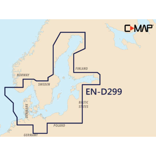
C-MAP REVEAL - Baltic Sea & Denmark
C-MAP
Low stock
Reveal M-EN Y299 Baltic Sea Most of Sweden (with western Jämtland partly gone and not quite at the top of the North) and Denmark with parts of N...
View full details
Original price
2 629 kr
Original price
2 629 kr
-
Original price
2 629 kr
Original price
2 629 kr
Current price
2 199 kr
2 199 kr
-
2 199 kr
Current price
2 199 kr
Sale
Original price
1 790 kr
Original price
1 790 kr
-
Original price
1 790 kr
Original price
1 790 kr
Current price
1 199 kr
1 199 kr
-
1 199 kr
Current price
1 199 kr
C-MAP DISCOVER - Malmö to Valdermarsvik
C-MAP
In stock
Discover M-EN Y207 Malmö-Valdemarsvik C-MAP Discover - whether you're cruising or fishing, C-MAP® DISCOVER™ provides a selection of cov...
View full details
Original price
1 790 kr
Original price
1 790 kr
-
Original price
1 790 kr
Original price
1 790 kr
Current price
1 199 kr
1 199 kr
-
1 199 kr
Current price
1 199 kr
Sale
Original price
1 790 kr
Original price
1 790 kr
-
Original price
1 790 kr
Original price
1 790 kr
Current price
1 599 kr
1 599 kr
-
1 599 kr
Current price
1 599 kr
C-MAP DISCOVER - Torekov to Larvik
C-MAP
Low stock
Discover M-EN Y206 Torekov-Larvik Discover has everything you need to make the most of your time on the water. Full vector graphics with high reso...
View full details
Original price
1 790 kr
Original price
1 790 kr
-
Original price
1 790 kr
Original price
1 790 kr
Current price
1 599 kr
1 599 kr
-
1 599 kr
Current price
1 599 kr
Sale
Original price
995 kr
Original price
995 kr
-
Original price
995 kr
Original price
995 kr
Current price
895 kr
895 kr
-
895 kr
Current price
895 kr
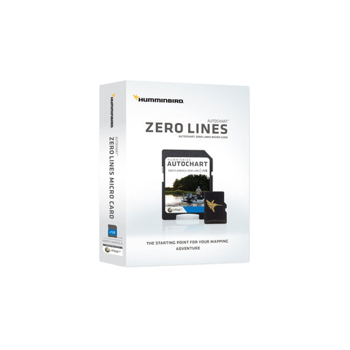
Humminbird AutoChart ZeroLine, SD card
Humminbird
In stock
Humminbird AutoChart ZeroLine Micro SD Card with SD Adapter. Contains basic map of European lakes. The base map only contains stand lines. ...
View full details
Original price
995 kr
Original price
995 kr
-
Original price
995 kr
Original price
995 kr
Current price
895 kr
895 kr
-
895 kr
Current price
895 kr
Sale

Original price
2 795 kr
Original price
2 795 kr
-
Original price
2 795 kr
Original price
2 795 kr
Current price
2 499 kr
2 499 kr
-
2 499 kr
Current price
2 499 kr
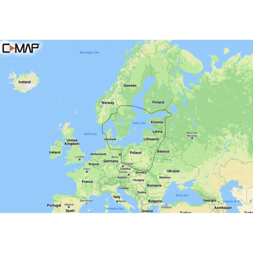
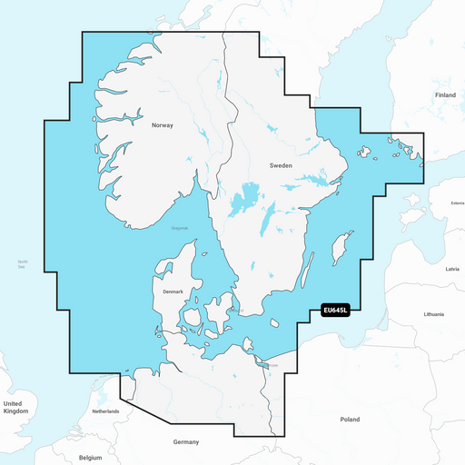
Garmin Navionics+ NSEU644L - Baltic Sea
Garmin
In stock
S Garmin Navionics+ charts feature vivid colors, a streamlined interface, and a combination of ocean and sea content with a popular Navionics®-s...
View full details
Original price
2 795 kr
Original price
2 795 kr
-
Original price
2 795 kr
Original price
2 795 kr
Current price
2 499 kr
2 499 kr
-
2 499 kr
Current price
2 499 kr
Sale
Original price
10 490 kr
Original price
10 490 kr
-
Original price
10 490 kr
Original price
10 490 kr
Current price
8 490 kr
8 490 kr
-
8 490 kr
Current price
8 490 kr
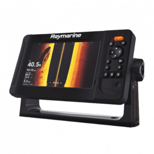
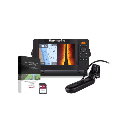
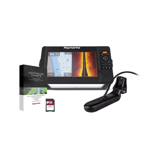
Raymarine - Element 7 HV - 7" MFD, HV-100 Transducer, LightHouse Chart
Raymarine
In stock
Raymarine - Element 7 HV - 7" MFD, HV-100 Transducer, LightHouse Chart Plotter/MFD with 7-inch screen, button controlled Fish smarter - abov...
View full details
Original price
10 490 kr
Original price
10 490 kr
-
Original price
10 490 kr
Original price
10 490 kr
Current price
8 490 kr
8 490 kr
-
8 490 kr
Current price
8 490 kr
Sale
Original price
1 795 kr
Original price
1 795 kr
-
Original price
1 795 kr
Original price
1 795 kr
Current price
1 695 kr
1 695 kr
-
1 695 kr
Current price
1 695 kr
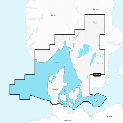
Garmin Navionics+ NSEU042R - Oslo to Trelleborg
Garmin
In stock
S Garmin Navionics+ charts feature vivid colors, a streamlined interface, and a combination of ocean and sea content with a popular Navionics®-s...
View full details
Original price
1 795 kr
Original price
1 795 kr
-
Original price
1 795 kr
Original price
1 795 kr
Current price
1 695 kr
1 695 kr
-
1 695 kr
Current price
1 695 kr
Sale
Original price
1 790 kr
Original price
1 790 kr
-
Original price
1 790 kr
Original price
1 790 kr
Current price
1 199 kr
1 199 kr
-
1 199 kr
Current price
1 199 kr
C-MAP DISCOVER - Karlskrona to Emden
C-MAP
Low stock
Discover M-EN Y205 Karlskrona-Emden C-MAP Discover - whether you're cruising or fishing, C-MAP® DISCOVER™ provides a selection of cover...
View full details
Original price
1 790 kr
Original price
1 790 kr
-
Original price
1 790 kr
Original price
1 790 kr
Current price
1 199 kr
1 199 kr
-
1 199 kr
Current price
1 199 kr
Sale

Original price
2 795 kr
Original price
2 795 kr
-
Original price
2 795 kr
Original price
2 795 kr
Current price
2 031 kr
2 031 kr
-
2 031 kr
Current price
2 031 kr
Navionics+ NAEU644L Östersjön (Baltic Sea)
Garmin
In stock
Detta Navionics+ NAEU644L Östersjön (Baltic Sea) Sjökort för inland (Gulf of Bothnia) sjökort är specifikt anpassat för ett brett utbud av kompati...
View full details
Original price
2 795 kr
Original price
2 795 kr
-
Original price
2 795 kr
Original price
2 795 kr
Current price
2 031 kr
2 031 kr
-
2 031 kr
Current price
2 031 kr
Sale

Original price
1 795 kr
Original price
1 795 kr
-
Original price
1 795 kr
Original price
1 795 kr
Current price
1 345 kr
1 345 kr
-
1 345 kr
Current price
1 345 kr
Navionics+ NAEU042R Oslo till Trelleborg
Garmin
In stock
Detta Navionics+ sjökort är specifikt anpassat för ett brett utbud av kompatibla plottrar. Detaljerade djupkurvor och dagliga uppdateringar gör de...
View full details
Original price
1 795 kr
Original price
1 795 kr
-
Original price
1 795 kr
Original price
1 795 kr
Current price
1 345 kr
1 345 kr
-
1 345 kr
Current price
1 345 kr
Sale
Original price
1 829 kr
Original price
1 829 kr
-
Original price
1 829 kr
Original price
1 829 kr
Current price
1 599 kr
1 599 kr
-
1 599 kr
Current price
1 599 kr
C-MAP DISCOVER X - Skagerrak, Kattegatt & Östersjön
C-MAP
In stock
Kasta loss med C-MAP Reveal X - det perfekta sjökortet för båtägare som använder Simrad NSX och B&G Zeus S-enheter. Detta omfattande sjökort l...
View full details
Original price
1 829 kr
Original price
1 829 kr
-
Original price
1 829 kr
Original price
1 829 kr
Current price
1 599 kr
1 599 kr
-
1 599 kr
Current price
1 599 kr
Sale
Original price
1 995 kr
Original price
1 995 kr
-
Original price
1 995 kr
Original price
1 995 kr
Current price
1 605 kr
1 605 kr
-
1 605 kr
Current price
1 605 kr
Navionics Nav+ 067R Svenska Sjöar
Navionics
In stock
Utforska världen under ytan med Navionics Nav+ sjökort! Med dessa avancerade kort får du en oöverträffad inblick i bottenstrukturen och djupen i ...
View full details
Original price
1 995 kr
Original price
1 995 kr
-
Original price
1 995 kr
Original price
1 995 kr
Current price
1 605 kr
1 605 kr
-
1 605 kr
Current price
1 605 kr
Sale

Original price
1 995 kr
Original price
1 995 kr
-
Original price
1 995 kr
Original price
1 995 kr
Current price
1 599 kr
1 599 kr
-
1 599 kr
Current price
1 599 kr
Humminbird Lakemaster VX Standard Sweden Sjökort
Humminbird
Out of stock
Humminbird LakeMaster VX Standard Sweden är ett sjökort som revolutionerar din fiskeupplevelse. Med avancerad teknologi, enastående prestanda och ...
View full details
Original price
1 995 kr
Original price
1 995 kr
-
Original price
1 995 kr
Original price
1 995 kr
Current price
1 599 kr
1 599 kr
-
1 599 kr
Current price
1 599 kr
Sold out

Original price
7 490 kr
Original price
7 490 kr
-
Original price
7 490 kr
Original price
7 490 kr
Current price
5 990 kr
5 990 kr
-
5 990 kr
Current price
5 990 kr
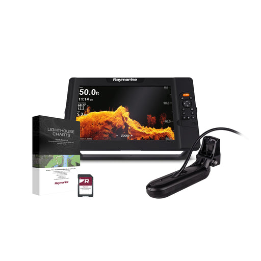
Raymarine Element 7 S - 7" MFD med Wi-Fi, GPS & LightHouse sjökort över norra Europa
Raymarine
In stock
Raymarine Element S-serien är din nyckel till smidig och prisvärd prestanda på sjön. Med en kraftfull fyrkärnig processor och en snabb och exakt 1...
View full details
Original price
7 490 kr
Original price
7 490 kr
-
Original price
7 490 kr
Original price
7 490 kr
Current price
5 990 kr
5 990 kr
-
5 990 kr
Current price
5 990 kr
Sale
Original price
1 790 kr
Original price
1 790 kr
-
Original price
1 790 kr
Original price
1 790 kr
Current price
1 599 kr
1 599 kr
-
1 599 kr
Current price
1 599 kr
C-MAP DISCOVER - Gulf of Bothnia
C-MAP
Out of stock
Discover M-EN Y209 Gulf Of Bothnia Discover has everything you need to make the most of your time on the water. Full vector graphics with high r...
View full details
Original price
1 790 kr
Original price
1 790 kr
-
Original price
1 790 kr
Original price
1 790 kr
Current price
1 599 kr
1 599 kr
-
1 599 kr
Current price
1 599 kr
Sold out
Original price
1 795 kr
Original price
1 795 kr
-
Original price
1 795 kr
Original price
1 795 kr
Current price
1 699 kr
1 699 kr
-
1 699 kr
Current price
1 699 kr
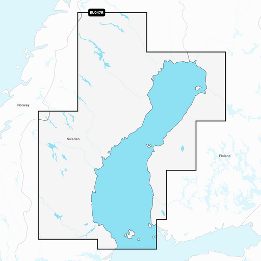
Garmin Navionics+ NSEU047R - Gulf of Bothnia
Garmin
In stock
The Garmin Navionics+ charts feature vibrant colors, a streamlined interface, and a combination of ocean and sea content with a popular Navionics®...
View full details
Original price
1 795 kr
Original price
1 795 kr
-
Original price
1 795 kr
Original price
1 795 kr
Current price
1 699 kr
1 699 kr
-
1 699 kr
Current price
1 699 kr
Sale
Original price
1 959 kr
Original price
1 959 kr
-
Original price
1 959 kr
Original price
1 959 kr
Current price
1 895 kr
1 895 kr
-
1 895 kr
Current price
1 895 kr
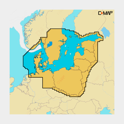
C-MAP 4D - Baltic Sea and Denmark
C-MAP
Low stock
This chart from C-MAP covers the entire Baltic Sea up to St. Petersburg as well as the Swedish and Finnish coasts including Denmark.
Original price
1 959 kr
Original price
1 959 kr
-
Original price
1 959 kr
Original price
1 959 kr
Current price
1 895 kr
1 895 kr
-
1 895 kr
Current price
1 895 kr
Sale

Original price
1 795 kr
Original price
1 795 kr
-
Original price
1 795 kr
Original price
1 795 kr
Current price
1 599 kr
1 599 kr
-
1 599 kr
Current price
1 599 kr
Navionics+ NAEU067R Sverige, sjöar och floder (Sweden, Lakes & Rivers)
Navionics
In stock
Detta Navionics+ NAEU047R Sverige, sjöar och floder (Sweden, Lakes & Rivers) sjökort är specifikt anpassat för ett brett utbud av kompatibla pl...
View full details
Original price
1 795 kr
Original price
1 795 kr
-
Original price
1 795 kr
Original price
1 795 kr
Current price
1 599 kr
1 599 kr
-
1 599 kr
Current price
1 599 kr
Sale

Original price
1 795 kr
Original price
1 795 kr
-
Original price
1 795 kr
Original price
1 795 kr
Current price
1 599 kr
1 599 kr
-
1 599 kr
Current price
1 599 kr
Navionics+ NAEU079R Sydöstra Sverige (Sweden, Southeast)
Garmin
In stock
Detta Navionics+ sjökort är specifikt anpassat för ett brett utbud av kompatibla plottrar. Detaljerade djupkurvor och dagliga uppdateringar gör de...
View full details
Original price
1 795 kr
Original price
1 795 kr
-
Original price
1 795 kr
Original price
1 795 kr
Current price
1 599 kr
1 599 kr
-
1 599 kr
Current price
1 599 kr
Sale

Original price
1 795 kr
Original price
1 795 kr
-
Original price
1 795 kr
Original price
1 795 kr
Current price
1 599 kr
1 599 kr
-
1 599 kr
Current price
1 599 kr
Navionics+ NAEU077R Danmark, Tyskland och Polens kust (Denmark, Germany & Coastal Poland)
Garmin
In stock
Detta Navionics+ sjökort är specifikt anpassat för ett brett utbud av kompatibla plottrar. Detaljerade djupkurvor och dagliga uppdateringar gör de...
View full details
Original price
1 795 kr
Original price
1 795 kr
-
Original price
1 795 kr
Original price
1 795 kr
Current price
1 599 kr
1 599 kr
-
1 599 kr
Current price
1 599 kr
Sale

Original price
3 995 kr
-
Original price
3 995 kr
Original price
3 995 kr
3 995 kr
3 995 kr
-
3 995 kr
Current price
3 995 kr
Garmin Navionics+ Vision NVEU644L Östersjön (Baltic Sea)
Garmin
In stock
Oavsett om du fiskar eller navigerar i grunda vatten ger detta Garmin Navionics+ Vision NVEU644L Östersjön (Baltic Sea) sjökort dig detaljerad inf...
View full details
Original price
3 995 kr
-
Original price
3 995 kr
Original price
3 995 kr
3 995 kr
3 995 kr
-
3 995 kr
Current price
3 995 kr

Original price
2 795 kr
Original price
2 795 kr
-
Original price
2 795 kr
Original price
2 795 kr
Current price
2 499 kr
2 499 kr
-
2 499 kr
Current price
2 499 kr
Garmin Navionics+ Vision NVEU079R Sverige, sydost (Sweden, South -East)
Garmin
In stock
Oavsett om du fiskar eller navigerar i grunda vatten ger detta Garmin Navionics+ Vision NVEU079R Sverige, sydost (Sweden, South -East) sjökort dig ...
View full details
Original price
2 795 kr
Original price
2 795 kr
-
Original price
2 795 kr
Original price
2 795 kr
Current price
2 499 kr
2 499 kr
-
2 499 kr
Current price
2 499 kr
Sale
Original price
13 490 kr
Original price
13 490 kr
-
Original price
13 490 kr
Original price
13 490 kr
Current price
9 989 kr
9 989 kr
-
9 989 kr
Current price
9 989 kr
Raymarine Element 9 HV - 9 MFD med HV-100 & LightHouse sjökort över norra Europa
Raymarine
In stock
Raymarine Element 9 HV är mycket mer än bara en plotter. Det är en komplett navigationslösning som ger dig överlägset övertag när du är ute på vat...
View full details
Original price
13 490 kr
Original price
13 490 kr
-
Original price
13 490 kr
Original price
13 490 kr
Current price
9 989 kr
9 989 kr
-
9 989 kr
Current price
9 989 kr
Sale
Original price
20 990 kr
Original price
20 990 kr
-
Original price
20 990 kr
Original price
20 990 kr
Current price
13 990 kr
13 990 kr
-
13 990 kr
Current price
13 990 kr
Raymarine Element 12 HV - 12 MFD med HV-100 & LightHouse sjökort över norra Europa
Raymarine
In stock
Raymarine Element 12 HV är mycket mer än bara en plotter. Det är en komplett navigationslösning som ger dig överlägset övertag när du är ute på va...
View full details
Original price
20 990 kr
Original price
20 990 kr
-
Original price
20 990 kr
Original price
20 990 kr
Current price
13 990 kr
13 990 kr
-
13 990 kr
Current price
13 990 kr
Sale
Original price
2 795 kr
Original price
2 795 kr
-
Original price
2 795 kr
Original price
2 795 kr
Current price
2 499 kr
2 499 kr
-
2 499 kr
Current price
2 499 kr
Garmin Navionics+ NSEU645L - Skagerrak and Kattegat
Garmin
In stock
S Garmin Navionics+ charts feature vivid colors, a streamlined interface, and a combination of ocean and sea content with a popular Navionics®-s...
View full details
Original price
2 795 kr
Original price
2 795 kr
-
Original price
2 795 kr
Original price
2 795 kr
Current price
2 499 kr
2 499 kr
-
2 499 kr
Current price
2 499 kr
Sale
Original price
1 795 kr
Original price
1 795 kr
-
Original price
1 795 kr
Original price
1 795 kr
Current price
1 599 kr
1 599 kr
-
1 599 kr
Current price
1 599 kr
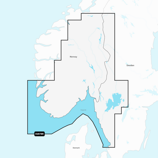
Garmin Navionics+ EU078R - Oslo - Skagerrak - Haugesund
Garmin
In stock
S Garmin Navionics+ charts feature vivid colors, a streamlined interface, and a combination of ocean and sea content with a popular Navionics®-s...
View full details
Original price
1 795 kr
Original price
1 795 kr
-
Original price
1 795 kr
Original price
1 795 kr
Current price
1 599 kr
1 599 kr
-
1 599 kr
Current price
1 599 kr
Sale

Original price
2 490 kr
Original price
2 490 kr
-
Original price
2 490 kr
Original price
2 490 kr
Current price
2 190 kr
2 190 kr
-
2 190 kr
Current price
2 190 kr
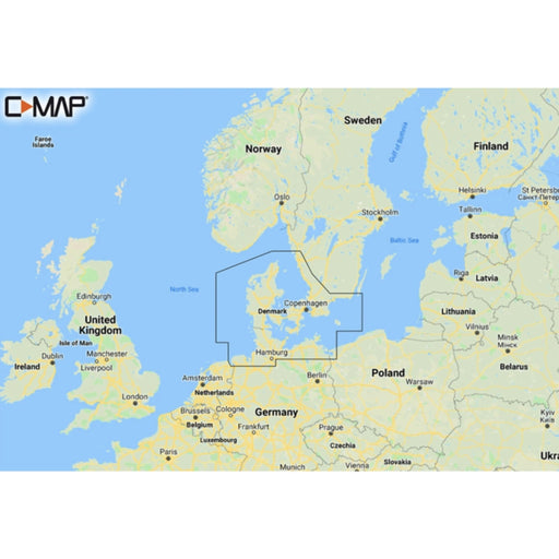
C-Map DISCOVER - Northern & Central Europe
C-MAP
In stock
Discover M-EN Y050 Northern & Central Europe Continental Discover has everything you need to make the most of your time on the water. Full v...
View full details
Original price
2 490 kr
Original price
2 490 kr
-
Original price
2 490 kr
Original price
2 490 kr
Current price
2 190 kr
2 190 kr
-
2 190 kr
Current price
2 190 kr
Sale

Original price
1 395 kr
-
Original price
1 395 kr
Original price
1 395 kr
1 395 kr
1 395 kr
-
1 395 kr
Current price
1 395 kr
Garmin Navionics+ Updates Blank - SD
Garmin
In stock
Genom att använda programmet Navionics Chart Installer kan du aktivera kortet och fortsätta få dagliga uppdateringar av kartdata, så att du alltid ...
View full details
Original price
1 395 kr
-
Original price
1 395 kr
Original price
1 395 kr
1 395 kr
1 395 kr
-
1 395 kr
Current price
1 395 kr

Original price
1 795 kr
Original price
1 795 kr
-
Original price
1 795 kr
Original price
1 795 kr
Current price
1 599 kr
1 599 kr
-
1 599 kr
Current price
1 599 kr
Navionics+ Download Regular
Garmin
Low stock
Navionics+ Regular is a series of charts that cover smaller areas of navigable waters in the North. The cards can be delivered blank or preloade...
View full details
Original price
1 795 kr
Original price
1 795 kr
-
Original price
1 795 kr
Original price
1 795 kr
Current price
1 599 kr
1 599 kr
-
1 599 kr
Current price
1 599 kr
Sale

Original price
2 995 kr
Original price
2 995 kr
-
Original price
2 995 kr
Original price
2 995 kr
Current price
2 899 kr
2 899 kr
-
2 899 kr
Current price
2 899 kr
Humminbird Lakemaster VX Premium Sweden Sjökort
Humminbird
In stock
Humminbird LakeMaster VX Premium Sweden är ett sjökort som låter dig ta dina fiskeupplevelser till nästa nivå. Med avancerad teknologi, enastående...
View full details
Original price
2 995 kr
Original price
2 995 kr
-
Original price
2 995 kr
Original price
2 995 kr
Current price
2 899 kr
2 899 kr
-
2 899 kr
Current price
2 899 kr
Sale

Original price
2 795 kr
Original price
2 795 kr
-
Original price
2 795 kr
Original price
2 795 kr
Current price
2 695 kr
2 695 kr
-
2 695 kr
Current price
2 695 kr
Navionics+ Blank Large (tomt kort)
Garmin
In stock
Navionics+ Blank Large är ett sjökort som skulle kunna liknas med vanliga papperssjökort, med en världsomfattande täckning. Notera att kortet är t...
View full details
Original price
2 795 kr
Original price
2 795 kr
-
Original price
2 795 kr
Original price
2 795 kr
Current price
2 695 kr
2 695 kr
-
2 695 kr
Current price
2 695 kr
Sale

Original price
3 695 kr
-
Original price
3 695 kr
Original price
3 695 kr
3 695 kr
3 695 kr
-
3 695 kr
Current price
3 695 kr
Navionics Platinum+ NPEU645L Södra Skandinavien och Norra Tyskland (Scandinavia, South & Germany, North)
Garmin
In stock
Med detta sjökort ges du som båtägare möjlighet att navigera med fullständig tillförlitlighet och precision, oavsett om du ger dig ut längs kusten...
View full details
Original price
3 695 kr
-
Original price
3 695 kr
Original price
3 695 kr
3 695 kr
3 695 kr
-
3 695 kr
Current price
3 695 kr

Original price
3 695 kr
-
Original price
3 695 kr
Original price
3 695 kr
3 695 kr
3 695 kr
-
3 695 kr
Current price
3 695 kr
Navionics Platinum+ NPEU644L Östersjön (Baltic Sea)
Garmin
In stock
Med detta sjökort ges du som båtägare möjlighet att navigera med fullständig tillförlitlighet och precision, oavsett om du ger dig ut längs kusten ...
View full details
Original price
3 695 kr
-
Original price
3 695 kr
Original price
3 695 kr
3 695 kr
3 695 kr
-
3 695 kr
Current price
3 695 kr

Original price
2 795 kr
-
Original price
2 795 kr
Original price
2 795 kr
2 795 kr
2 795 kr
-
2 795 kr
Current price
2 795 kr
Navionics Platinum+ NPEU067R Sverige, sjöar och floder (Sweden, Lakes & Rivers)
Garmin
In stock
Med detta sjökort ges du som båtägare möjlighet att navigera med fullständig tillförlitlighet och precision, oavsett om du ger dig ut längs kusten ...
View full details
Original price
2 795 kr
-
Original price
2 795 kr
Original price
2 795 kr
2 795 kr
2 795 kr
-
2 795 kr
Current price
2 795 kr

Original price
2 795 kr
-
Original price
2 795 kr
Original price
2 795 kr
2 795 kr
2 795 kr
-
2 795 kr
Current price
2 795 kr
Navionics Platinum+ NPEU047R Bottenviken (Gulf of Bothnia)
Garmin
In stock
Med detta sjökort ges du som båtägare möjlighet att navigera med fullständig tillförlitlighet och precision, oavsett om du ger dig ut längs kusten...
View full details
Original price
2 795 kr
-
Original price
2 795 kr
Original price
2 795 kr
2 795 kr
2 795 kr
-
2 795 kr
Current price
2 795 kr

Original price
2 795 kr
-
Original price
2 795 kr
Original price
2 795 kr
2 795 kr
2 795 kr
-
2 795 kr
Current price
2 795 kr
Navionics Platinum+ NPEU079R Sydöstra Sverige (Sweden, Southeast)
Garmin
In stock
Med detta sjökort ges du som båtägare möjlighet att navigera med fullständig tillförlitlighet och precision, oavsett om du ger dig ut längs kusten...
View full details
Original price
2 795 kr
-
Original price
2 795 kr
Original price
2 795 kr
2 795 kr
2 795 kr
-
2 795 kr
Current price
2 795 kr

Original price
2 795 kr
-
Original price
2 795 kr
Original price
2 795 kr
2 795 kr
2 795 kr
-
2 795 kr
Current price
2 795 kr
Navionics Platinum+ NPEU042R Oslo till Trelleborg
Garmin
In stock
Med detta sjökort ges du som båtägare möjlighet att navigera med fullständig tillförlitlighet och precision, oavsett om du ger dig ut längs kusten...
View full details
Original price
2 795 kr
-
Original price
2 795 kr
Original price
2 795 kr
2 795 kr
2 795 kr
-
2 795 kr
Current price
2 795 kr

Original price
2 795 kr
-
Original price
2 795 kr
Original price
2 795 kr
2 795 kr
2 795 kr
-
2 795 kr
Current price
2 795 kr
Navionics Platinum+ NPEU078R Oslo, Skagerrak och Haugesund
Garmin
In stock
Med detta sjökort ges du som båtägare möjlighet att navigera med fullständig tillförlitlighet och precision, oavsett om du ger dig ut längs kusten ...
View full details
Original price
2 795 kr
-
Original price
2 795 kr
Original price
2 795 kr
2 795 kr
2 795 kr
-
2 795 kr
Current price
2 795 kr

Original price
2 795 kr
-
Original price
2 795 kr
Original price
2 795 kr
2 795 kr
2 795 kr
-
2 795 kr
Current price
2 795 kr
Navionics Platinum+ NPEU077R Danmark, Tyskland och Polens kust (Denmark, Germany & Coastal Poland)
Garmin
In stock
Med detta sjökort ges du som båtägare möjlighet att navigera med fullständig tillförlitlighet och precision, oavsett om du ger dig ut längs kusten ...
View full details
Original price
2 795 kr
-
Original price
2 795 kr
Original price
2 795 kr
2 795 kr
2 795 kr
-
2 795 kr
Current price
2 795 kr

Original price
2 795 kr
Original price
2 795 kr
-
Original price
2 795 kr
Original price
2 795 kr
Current price
2 199 kr
2 199 kr
-
2 199 kr
Current price
2 199 kr
Navionics+ NAEU645L Södra Skandinavien och Norra Tyskland (Scandinavia, South & Germany)
Garmin
In stock
Detta Navionics+ NAEU645L Södra Skandinavien och Norra Tyskland (Scandinavia, South & Germany, north) sjökort är specifikt anpassat för ett bre...
View full details
Original price
2 795 kr
Original price
2 795 kr
-
Original price
2 795 kr
Original price
2 795 kr
Current price
2 199 kr
2 199 kr
-
2 199 kr
Current price
2 199 kr
Sale

Original price
1 795 kr
Original price
1 795 kr
-
Original price
1 795 kr
Original price
1 795 kr
Current price
1 599 kr
1 599 kr
-
1 599 kr
Current price
1 599 kr
Navionics+ NAEU047R Bottenviken Sjökort för inland (Gulf of Bothnia)
Garmin
In stock
Detta Navionics+ NAEU047R Bottenviken Sjökort för inland (Gulf of Bothnia) sjökort är specifikt anpassat för ett brett utbud av kompatibla plottra...
View full details
Original price
1 795 kr
Original price
1 795 kr
-
Original price
1 795 kr
Original price
1 795 kr
Current price
1 599 kr
1 599 kr
-
1 599 kr
Current price
1 599 kr
Sale